The Polar Data Discovery Enhancement Research (POLDER) Polar Federated Search (PFS) portal was created for the polar research community to make Arctic and Antarctic data more readily available, enabling anyone and everyone interested in polar data to search across a growing number of polar data repositories with a single query. PFS is an open source project that complements and integrates with our work supporting polar data semantic harmonization and markup as part of the international polar research community. This past month the ITO released an upgrade to the PFS results options and the completion of the first iteration of the POLDER Best Practice Guide.
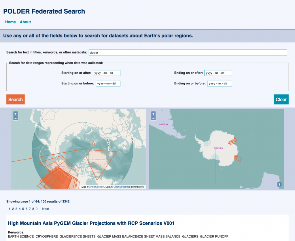
ITO staff Melinda Minch and Yemisi Ogungbemi created and added polar projection maps that show the locations of data in datasets that appear in the POLDER Federated Search results. Having a map display to accompany a search is the first stage of enabling the map search feature. Map searching is a recommended search interface for geospatial data and accommodates varying search strategies among polar data researchers, users, and data managers. In this first iteration, a simple or advanced search in the Polar Federated Search will provide a list of matching data and their projections on the Arctic and Antarctic maps visually as orange highlighted areas. These areas represent the spatial coverage of each dataset. The next stage of the map projection development will enable click actions for the projected datasets. Clicking on an orange rectangle will open an information window that contains details about the represented dataset, and the option to jump to that search result. The eventual goal is for users to be able to draw areas on the map to find datasets within them.

In addition to the recent update in the Polar Federated Search, the recent completion and posting of the POLDER Schema.org Best Practice Guide version 1.0 is a major milestone toward polar data discoverability and interoperability. With ITO staff member Chantelle Verhey as one of the lead authors, this guide builds on existing Earth science community standards and approaches to harmonized metadata, such as the Science-on-Scehma.org metadata guidance documents, and incorporates the needs of polar research through key use cases. The data discovery requirements collected for polar metadata represent a target set of features for the PFS and the data discoverable through it. The guidance documents clearly lay out uniform best practices for data managers who want to document polar data, observing assets, and other entities. By collecting these community-supported requirements in one place, they can be recommended to polar data repositories for implementation so that their data is compatible with, and can be included in, the PFS, increasing the discoverability of their data.
Congratulations on work well done, Chantelle, Yemisi, and Melinda!
Stay tuned for more updates to the Polar Federated Search and POLDER community by subscribing to our news feed.
Additional Information:
- POLDER Federated Search
- POLDER Best-Practices-schema.org GitHub
- POLDER Schema.org Best Practice Guide (Google Doc)
- Related news post: ESIP endorses ITO coauthored metadata guidance